|
Introduction
Welcome to the CLIP (Climate Land Interaction Project)
web site at Michigan State University. The overall objective of
this research project is to understand the nature and magnitude
of the interactions of climate and land use/cover change across
East Africa. Researchers are employing a variety of tools to understand
these important linkages. These include the use of regional atmospheric
models, crop production models, land use/cover change models,
satellite remote sensing, role playing simulations and household
survey information. Data from several case study areas, located
along ecological gradients located on prominent volcanoes (e.g.,
Mt Kilimanjaro and Mt. Kenya) are being used to build high resolution
models that can be scaled up to the region.
Our
research team is composed of climatologists, experts in land use/cover
change, remote sensing, meteorology, geographic information
systems and ecology.
The study region focused principally on Kenya, Uganda
and Tanzania but it also includes portions of: Ethiopia, Somalia,
Sudan, Rwanda, Burundi, Zaire, Zambia, Malawi and Mozambique.
 Funding
for the project: An Integrated Analysis of Regional Land-Climate Interactions, BE/CNH Award No. 0308420, is from
the National Science Foundation Biocomplexity
of Coupled Human and Natural Systems Program
and the Michigan State University Foundation. Funding
for the project: An Integrated Analysis of Regional Land-Climate Interactions, BE/CNH Award No. 0308420, is from
the National Science Foundation Biocomplexity
of Coupled Human and Natural Systems Program
and the Michigan State University Foundation.
The Dynamic Interactions among People, Livestock, and Savanna Ecosystems under Climate Change, Award No. BCS/CNH 0709671, from
the National Science Foundation Biocomplexity of Coupled Human and Natural Systems Program, is a follow up to the Climate Land Interaction project and can be accessed at http://www.eaclipse.msu.edu/
The CLIP project is a follow up to the Land Use Change, Impacts and Dynamics (LUCID) project. LUCID is a network of scientists at leading national and international institutions who have been studying land use change in East Africa and its implications for land degradation, biodiversity, and climate change. The LUCID project is available at http://www.lucideastafrica.org/
Addressing the Impact of Climate Change on Agricultural Systems in East Africa, is a new project funded by a Rockefeller Foundation grant. CLIP and Eaclipse researchers at Michigan State University and in Kenya, Tanzania, and Uganda will study the impact of climate change on agricultural systems in East Africa. Project information is available at
http://www.rockefellerfoundation.org/grants/grants-and-grantees/1264081 |
The following images were provided by CLIP researchers while in Kenya conducting spectormetry measurements and ground truthing.
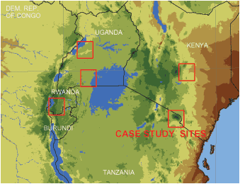
Click on the map to view the entire study region. (181 KB - PDF)
|