|
Research
overview | systems | climate | land use | land cover
Remote Sensing Parameterization
of Land Cover. This work is focusing on the transformation
of categorical land use information into quantitative land surface
physical parameters. The parameters that will result from this
analysis, and that will be inputs to the regional climate model,
include surface albedo, fractional vegetative cover, leaf area
index (both senescence and green) and above ground biomass. A
nested scale analysis using current MODIS/ ASTER imagery with
ETM+ imagery will better capture the land cover dynamics especially
in semi-arid areas where vegetation signals are difficult to extract.
The advantage of the nested scale approach is that the imagery
data will provide improved parameters over large areas and the
data are compatible to both field based observations and global
circulation models. This method has been successfully applied
elsewhere by a team member (J. Qi), and the data and information
from East Africa will further validate this approach especially
for semi-arid tropical areas. The method being applied here, of
upscaling from land use/ cover to MODIS imagery, will provide
informational benefits for global change scientists working in
other areas of Africa and the tropics. The data and information
on East Africa resulting from this activity will be extremely
useful for scientists conducting global circulation modeling. |
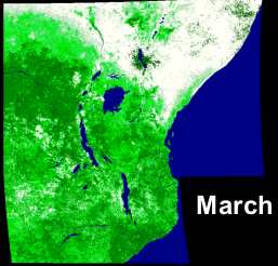
Leaf area index (LAI) for March 2001 derived from MODIS
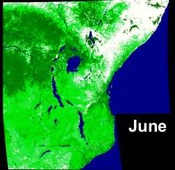
Leaf area index (LAI) for June 2001
|