|
Research
overview | systems | climate | land use | land cover
Matrix of Experiments
The
regional climate model that we are using is based on the Regional
Atmospheric Modeling System (RAMS, Pielke et al. 1992). Lofgren
(2000) has refined the version used here under the name Coupled
Hydrosphere-Atmosphere Research Model (CHARM) in order to make
it more useful for simulations over long time periods. Some additional
adjustment may need to be made to make it better suited to the
needs of the current project. In particular, the convective precipitation
scheme may benefit from some adjustment in order to work more
satisfactorily in a tropical setting. The input data that are
required to drive CHARM include lower boundary conditions and
lateral boundary conditions. The lower boundary conditions that
are required are specification of land and water fractions within
each grid square, plus land cover type. Land surface parameterizations
can be adapted to accommodate additional land cover types, multiple
land cover types within one grid square, and seasonal variation
of vegetation characteristics
As
a proof of concept for using a regional climate model as a part
of the overall study, a regional climate model based on RAMS was
run for the first two months of 1993 for two experimental cases,
with additional simulations currently pending. The two cases that
have been run represent one case with an approximation of present-day
land cover, albeit at a coarse resolution (vegetated case), and
a case of extreme desertification, with all vegetation removed
and only bare soil remaining (unvegetated case). The model was
parameterized with 40-km grid spacing, while the vegetation in
the vegetated case was specified on a 1-degree grid (approximately
110 km), but we plan to improve the resolution of the vegetation
input. The bare soil prevents any withdrawal of moisture from
the soil other than immediately at the surface, resulting in little
evapotranspiration.
Although
the direct effect is on the evapotranspiration, a more striking
transformation occurs in the simulation sensible heat flux. The
vegetated case during February 1993 shows a pattern in which the
sensible heat flux (Fig. 1a) is high (much heat is transferred
from the surface to the atmosphere) where the surface is specified
as grassland, especially toward the eastern edge (upwind in prevailing
conditions) of those zones, and lower in the savanna regions.
This is complemented by the rates of evapotranspiration or latent
heat flux (not shown), which are higher in the savanna regions
than in the grasslands. The unvegetated case shows a very different
pattern (Fig. 1b), with a land breeze cell developing near the
Indian Ocean coast and dissipating the clouds there. This results
in high insolation near the coast and, combined with the lack
of evapotranspiration from the land in this case, values of sensible
heat flux are far higher than any simulated in the vegetated case.
Under
a more reasonable land use/land cover transformation, the results
could not be expected to be as dramatic as this, but localized
alterations of energy fluxes are very likely to be a result. Changes
in large-scale circulation cloud also result within the study
area. The model domain could also be expanded, using multiple
nesting at varying resolutions, to include most of Africa and
the Indian Ocean, to enable such scenarios as deforestation of
the Congo. Finer-scale grids can also be nested into the 40-km
grid over limited regions.
|
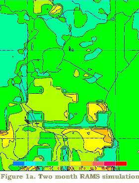
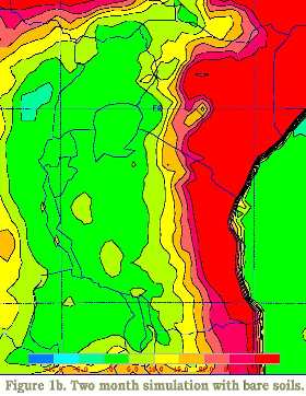
RAMS
simulations for current vegetation (Fig 1a)
and no vegetation (Fig 1b). The two month simulation
represented 1993 conditions. |