|
Research
overview | systems | climate | land use | land cover
Represent the Decisions of Agents
in Changing Land Use. An innovation in modeling the impact of climate change on land
use is represented by our MABEL
(Multi-Agent Based Economic Landscape) Model. The agent-based
model (cf. Sallach, 2001; Box, 2002; Gimblett, 2002) simulates
the economics of land transitions. MABEL (Alexandridis and Pijanowski,
2002) currently has three types of agents: sellers, buyers and
land use planners. Buying and selling is determined by each individual’s
economic utility for all potential land use types (urban, agriculture,
forest or wetland). The utility function is also Bayesian; thus
previous decisions and the probability of a land transaction (to
buy, sell or not to sell). Learning is introduced into the utility
function enabling the agents to “adapt” the best strategies.
The model is parcel based so that the buying and selling of a
portion of a parcel is factored into the model. Once the model
is initiated, the model updates each individual agent’s
utility values in a Bayesian fashion; all values are thus changed
during each time step. These values are then saved and are analyzed
in relationship to patterns of parcelization and land use.
We
intend to explore a variety of methods to parameterize a MABEL-like
model for East Africa. Case study areas currently have the requisite
information required for a MABEL-like model: parcel, land use/cover
data and household survey information for several time periods.
Parcel data and associated land use, household survey and biophysical
attributes exist for all of the case study sites. We recognize
that there will be a variety of different types of agents that
will interact in complex hierarchies. In southern Kenya, for example,
land use categories exist that both conflict and complement each
other in terms of resource management, economic objectives, and
environmental sustainability. These include herding, farming,
and wildlife-based tourism. Different actors engage in these land
uses, and decisions on resource allocation are contingent upon
legal, political, and ethnic institutions and relationships. For
example, an elected committee administers group ranches in this
area with a chairman, secretary and treasurer. This committee
manages broad policy issues. Individual members take decisions
regarding size of herds, when and where to graze and water livestock,
and on cropping strategies, and expected income from each crop,
etc. As land managers these individuals will respond differently
to climate dynamics, to the relatively static biophysical environment
(soils, topography, hydrography), and to cultural traditions,
economic opportunities, policy initiatives, and relationships
with land managers in other adjacent land use systems.
Capture
Society’s Decision Making as it Responds to External Driving
Forces. A third approach to modeling
will be game or role playing simulations. Such simulations are
long established in the fields of military science and the social
sciences. They are designed to allow actors representing key individuals,
groups, and institutions to interact to address hypothetical scenarios.
The outcomes yield specific results in terms of prospective effects
of specified initial conditions and drivers of change. For example
in resource conflict simulations, maps illustrate the outcomes
of discussion and debate over economic, social, policy, and environmental
concerns. Equally important are insights to the process of decision-making
by individuals and groups, including alliance formation and application
of power or force.
The
team will build on an existing role playing simulation of land
use change in East Africa (Campbell and Palutikof 1978; Shoemaker
1998) to examine the impact of climate change, defined by output
from climate change scenarios and crop-climate models. The databases
developed for the project will serve as a basis for updating the
information base on which the simulation will be run.
There
will be two categories of output important to the project. First,
future land use change will be projected based on specified initial
conditions and introduced changes in climate and related crop
and vegetation conditions. The participants will represent their
output in map format. These maps will be compared with those derived
from other modeling procedures. Second, the interactions between
actors will be documented and used to parameterize the MABEL model.
The research team will take notes on communication pathways, strategies
and behaviors that result from different types of information/contexts
provided them and that we establish goals. We are conducting 2
role playing simulations; one representing individual decisions
and another representing a resource manager’s decision regarding
land management.
Incorporate
Opinions and Beliefs Affecting Land Use Decisions.
Our fourth approach, the integration of individual and group Belief
Networks (Gill 2002), will allow the team to combine the results
of the agent and role playing simulation as well as serve as another
example of modeling. Belief Networks allow users to diagram how
they perceive cause and effect relationships between components.
The probability of the cause-effect relationship, recorded on
a continuous or Likert scale, are introduced in a Markov or Bayesian
fashion. As new evidence is introduced to the Belief Network,
the probability of certain outcomes changes. For example, as the
climate gets warmer and drier, the likelihood that individuals
will shift from fruit and vegetables to a row crop such as maize
increases.
|
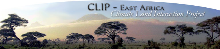
Causal Inference Model that is the Bayesian behavioral
component in MABEL.
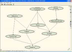
Causal
Inference Model that shows probability distribution
for land uses
for each input configuration.
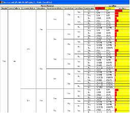
The
result of presenting different evidence varying climate
and its
effect on land use preferences. |